GIS Day — November 20
Posted November 20, 2024

Happy GIS day!
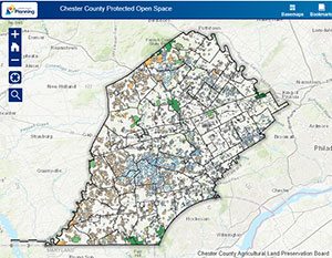
CCPC's GIS team is hard at work every day. In fact, they've been working to update our protected open space mapping to reflect the actual preserved land more accurately, rather than just showing the parcels that contain preserved land.
This started with CCPC's former intern Nick Ogborn, who updated the Homeowners Association (HOA) open space boundaries to remove impervious surfaces, which are not considered "open space". The acreage of the new open space boundary was calculated by Nick and then updated by Jake Michael, CCPC's Senior Demographer, in our POST (Protected Open Space Tracking) system.
This was followed by CCPC acquiring conservation easement boundaries in the form of agricultural easements (from Chester County Parks & Preservation) and land trust easements (from various sources including the Land Trusts themselves and from WeConservePA). Again, these easements show the actual boundary of the land that is eased, not the parcel on which the eased land is on. This is the step our GIS team is currently working on.
The goal is to collect as many accurately mapped easements as possible to display them on CCPC's POST interactive map. By doing so, the public will have a better idea of where land is actually preserved in Chester County.
Thanks to our amazing GIS team (and those who support it) and our GIS Planner, Colin Murtoff, for the update!

